
Helpdesk & PPM Work Locations and Mapping
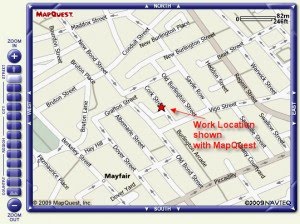
Helpdesk & PPM work locations can often be made clearer, by showing a map to operators and service providers alike. Existing technology means showing where a work location is on a street is quite straightforward. A number of different methods exist, whereby a postcode or more precisely longitude and latitude, and drive mapping engines like Google or Mapquest, to show within a few metres, exactly where a building is located.
Some elements of data are very specific to the application that required them, but longitude and latitude angles are “hundred year data”, in that they are very unlikely to be superseded by “better” location information, and can be utilised by map systems, GPS systems, routing systems, and any other application which works with precise location data.
The FastTrack software uses maps in conjunction with Labour Resource Planning and building data, generally: http://www.fasttrackhelpdesk.com/